What on earth is an EPSG Code?
The European Petroleum Survey Group (EPSG) is a noble scientific organisation with heavy ties to the European petroleum industry.
Or at least, it used to be. It was absorbed by IOGP (International Association of Oil & Gas Producers) in 2005 and ceased operation as an independent body.
We don’t remember EPSG for its history as an entity, but rather for the database that it compiled. EPSG created the EPSG Geodetic Parameter Set – a comprehensive database of coordinate reference systems, datums, ellipsoids, and other such geodetic parameters. Although EPSG as an organisation is no more, its database lives on and is still updated and maintained.
Each entry in the EPSG database has a unique code associated with it. These codes are known as EPSG codes and they seem to be found everywhere that spatial data lurks.
An EPSG code might refer to a:
- Coordinate Reference System (CRS) – like EPSG4326, which refers to the coordinate reference system WGS 84.
- Datum – like EPSG 6326, which refers to the datum used in the coordinate reference system WGS 84.
- Area of use – like EPSG 1262, which refers to the entire world.
- Prime Meridian – like EPSG 8901, which refers to the meridian passing through Greenwich.
This is not a comprehensive list. EPSG codes also refer to ellipsoids, spheroids and miscellaneous other things.
For further illustration here is the EPSG structure for WGS 84, a commonly used geographic Coordinate Reference System:
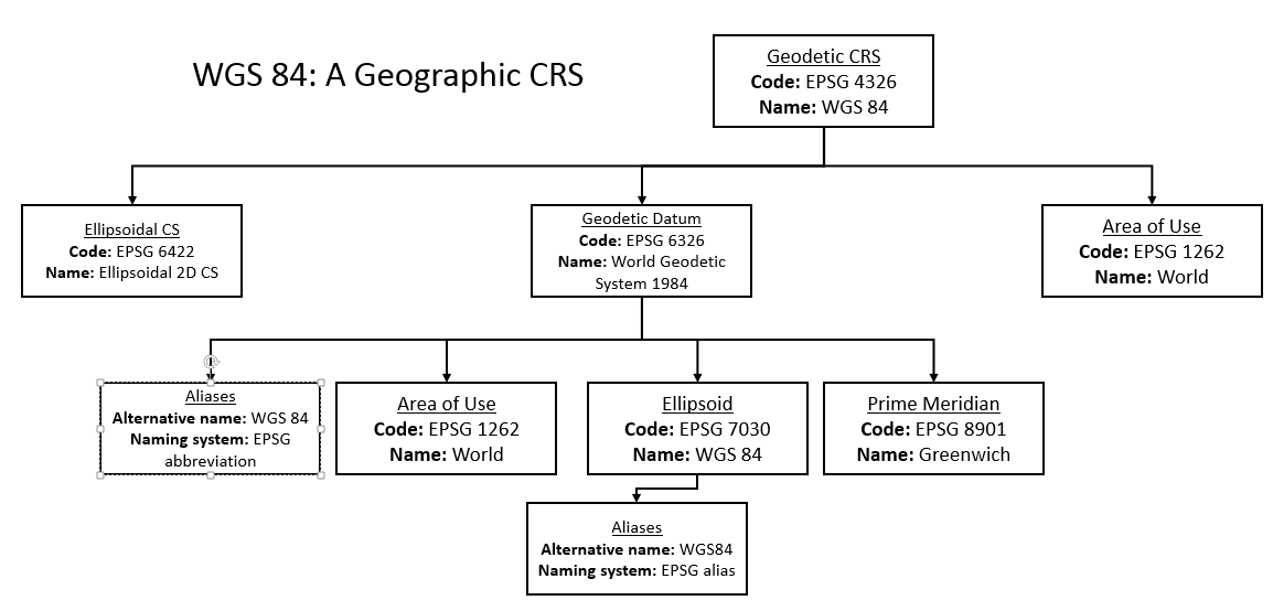
Evidently, many EPSG codes together make up the WGS84 coordinate system. The name WGS84 appears three times in this hierarchy: under the entries for Geodetic CRS, Geodetic Datum and Ellipsoid, and as such the use of this code is ambiguous. The code EPSG 4326 by contrast is unambiguous: it refers only to the coordinate reference system, not the ellipsoid or the geodetic datum.
Next time you meet an EPSG code in the wild, you’ll be prepared.